
Global Positioning System
From Indonesian Wikipedia, the free encyclopedia
Global Positioning System ( GPS ) is the only satellite navigation systemis functioning properly. The system uses 24 satellites that transmit signals microwaves to Earth. This signal is received by a receiver on the surface, and is used to determine position, velocity , direction, andtime . System similar to GPS among other GLONASS Russian , GalileoEuropean Union , IRNSS India .
The system was developed by the U.S. Department of Defense , with his full name is NAVSTAR GPS (common mistake is that the NAVSTAR is anacronym , it is wrong, NAVSTAR is the name given by John Walsh, an important determinant of policy in the GPS program). [1] This satellite collection maintained by the 50th Space Wing United States Air Force .System maintenance costs are around U.S. $ 750 million per year, [2]including the replacement of old satellites, as well as research and development.
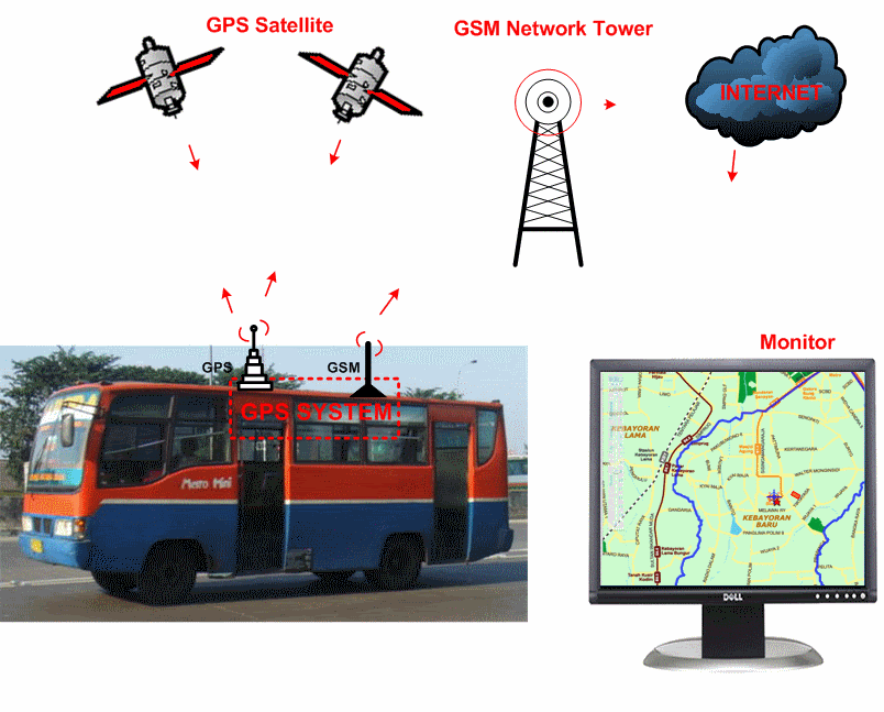
GPS Tracker is often called the GPS Tracking technology is the AVL (Automated Vehicle Locater) that allows users to track the position of the vehicle, or fleet car in the state of Real-Time. GPS Tracking utilizing a combination of GSM and GPS technology to determine the coordinates of an object, and then translate it in the form of digital maps.
How it Works
This system uses a number of satellites in earth orbit, which transmits the signal to Earth and was captured by a receiver. There are three important parts of this system, namely the control, the sky, and the user.
Control section
As the name suggests, this section is to control. Each satellite may be slightly out of orbit, so that part is tracking the satellite orbit, location, altitude, and speed. Sari satellite signals received by the control section, corrected, and sent back to the satellite. Correction of data the exact location of the satellite ephemeris data is referred to, which will be sent to our navigation tool.
Space section
This section consists of a collection of satellites that are in earth orbit, about 12,000 miles above the earth's surface. Collection of these satellites are arranged so that the navigation tool at any time can receive signals from at least four satellites. Satellite signals can pass through clouds, glass, or plastic, but can not pass through buildings or mountains. Satellites have atomic clocks, and will also be transmitting information 'time / clock' this. Data is transmitted by the code 'pseudo-random'. Each satellite has its own code. This code number will usually be displayed in a navigation tool, then we can identify the satellite signal is being received by the apparatus. This data is useful for the navigation tool to measure the distance between the satellite navigation equipment, which will be used to measure the coordinates of the location.Satellite signal strength will also help in the calculation tool. The signal strength is more influenced by the location of the satellite, a device will receive a stronger signal from the satellite which is right above it (think satellite locations such as the position of the sun when the hours of 12 pm) compared to the satellites that are in the horizon (think satellite locations such as the sun goes down / published).
There are two types of waves that are currently used for satellite-based navigation tools in general, the former is better known as L1 at 1575.42 MHz. L1 signal is to be received by the navigation tool. Satellites also issued a wave at a frequency of 1227.6 MHz L2. L2 wave is used for military purposes and not for the public.
The user part
This section consists of a navigation tool that is used. The satellite will transmit the ephemeris and almanac data to be received by the navigation tool on a regular basis. Almanac data contains the approximate location (approximate location) satellites continuously emitted by the satellite. Data transmitted by the satellite ephemeris, and valid for about 4-6 hours. To show the coordinates of a point (two dimensional), a navigation tool requires at least 3 pieces of the satellite signal. To demonstrate a point elevation data (three dimensional), required an additional signal from a satellite fruit again.
Of the signals emitted by a collection of satellites, a navigation tool will perform calculations, and the end result is the coordinate position of the tool. Greater the number of satellite signals received by an instrument, will make the tool calculates the coordinates of its position more precisely.
Because the full navigation tool is dependent on the satellite, the satellite signals are very important. This satellite-based navigation tool can not work optimally when there is interference with satellite signals. There are many things that can reduce the signal strength of satellites:
- Geographical conditions, as described above. As long as we still can see the sky that is wide enough, this tool can still function.
- Forest. The more dense forest, then the less the signal can be received.
- Water. Do not expect to use this tool when diving.
- Car window film, especially those containing metal.
- Electronic tools that can output an electromagnetic wave.
- Buildings. Not only when inside the building, located between 2 pieces of a tall building would also cause such effects are in the valley.
- Signals that bounce, ie when it is between tall buildings, can mess up the calculation so that the navigation device navigation device can indicate the position of the incorrect or inaccurate.
Antenna
There are two types of antennas innate navigational tools most commonly found, namely the type and Quad Helix Patch. Patch types, flat shape while quad helix shaped like a tube. Obviously both have their advantages and disadvantages of each. In the everyday use, many factors that affect its function. Navigation tool that has a patch antenna, the signal reception would be better if the tool is held parallel to the earth flat.While the tool has a Quad helix antenna, will be better when held upright, the top towards the sky. To be sure, check the specifications of antennas navigation tool.
In the everyday use, it is often necessary external antenna, for example, the use of vehicles within the four wheels. There are several types of external antennas that can be selected. Keep in mind that not all types of navigation devices have a slot for an external antenna.
- Active external antenna called active because it is equipped with a Low Noise Amplifier (LNA), a signal amplifier, since the signal will be reduced when crossing the wire. That is, this kind require a power source to perform its function, which typically drawn from a navigation tool. So that means the battery will run out faster navigation. Profits, the cable can be used longer than the passive type.
- Passive external antenna is not equipped Because the signal amplifier, the batteries do not run out quickly. But the cables can not be used during the active type.
- Re-radiating antenna eksernal this type consists of two parts, the first capture satellite signals, which both emit signals.Since the signal is emitted, then it does not require any type of cable connection to a navigation tool. Navigation devices will receive the signal as usual. Of course this kind require an additional power source, but not from a navigation tool that is used. For the type of navigation tool that does not have a slot for an external antenna, this type is a good alternative than having to modify the navigation tool.
- Combo Antenna Antenna type is a merger between the antenna for navigation devices and mobile phones. The power source is required for its use.
Keep in mind that the coordinates displayed by the navigation tool is the coordinate position of an external antenna. Thus, the placement of an external antenna is also noteworthy.
DGPS
DGPS (Differential Global Positioning System) is a system or a way to improve the GPS, using the ground station, which transmits the correction location. With this system, then as a navigation tool to receive corrections and insert it into the calculation, the accuracy of navigational tools will increase. Therefore, using ground stations, then the signal can not cover a large area.
Although it has a difference in the way of working, SBAS (Satellite Based Augmentation System) in general can be said is that using satellite DGPS.Coverage area is much broader than the use DGPS ground stations. There are several SBAS which is known, the WAAS (Wide Area Augmentation System), EGNOS (European geostationary Navigation Overlay Service), and MSAS (Multi-functional Satellite Augmentation System). Managed by the U.S. WAAS, EGNOS by the European Union, and the Japanese MSAS. These three systems are mutually compatible with one another, that is a navigation tool that can use one system, will be able to use both systems as well. At this time the only WAAS is fully operational and can be enjoyed by the user's navigation tools in the world. However, a DGPS ground station that works well, can improve the accuracy exceeds / equals the increase that can be achieved by SBAS.
In general, can be divided into two major parts, namely "real time (live)" and "Post processing (after the completion of activities)". The purpose of the 'real time' is a navigation tool that uses SBAS or DGPS signals currently used directly. While the 'post processing' means that the data collected by the navigation tools in the process of re-using data from the DGPS ground stations. There are many DGPS ground stations around the world that we can use for this, both free and paid versions, you can even use it directly through the internet.
Although DGPS or SBAS can improve accuracy, but the terms containing the correction signals sent to the area where we are using a navigation tool.If it does not contain the corrections to the data for the region, will not increase accuracy.
Some sense of the term
- Cold & Warm startIn the detail specifications of navigation tools, usually written the time required for cold and warm start. When the navigation device is turned off, the appliance is still storing the satellite data are 'locked' before. One of the stored data is ephemeris data, and data is still valid for about 4-6 hours (for easier, use the reference time of 4 hours only). When turned on again, then the tool will look for satellite navigation based on the data store. When the data is still stored in the said period, then datadata can still be used by satellite navigation devices to lock, and cause faster navigation tools to lock the satellite.This is called "Warm start". When the stored data was outdated, it means exceeding the above period, it can not use the navigation tool. So that the navigation tools to start the whole process from scratch, and lead time needed to be much longer.This is called "Cold start". The whole process only takes a few minutes.
- Waterproof IPX7Standards were made by the IEC (International Electrotechnical Commission), the first number describes the robustness testing tool against solid objects, and the second number describes the resistance to liquid (water). When the tool is only tested against one state (solid or liquid), then the letter 'X' is placed on the first or second rate.IP X7 means: X indicates the tool is tested against a solid object, while the number 7 means it can be soaked in water with a depth of 15 cm - 1 meter (on the garmin website added: 30 minutes). Full details can be viewed at the a
- RoHS versionIn the manual of satellite-based navigation tool, these specifications may be found. This is a provision made by the European Union restrictions on the use of six types of hazardous materials in electronic equipment manufactured after July 1, 2006. RoHS stands for Restriction of use of Certain Hazardous Substances. Six types of restricted material is Cadmium (Cd), Mercury / mercury (Hg), hexavalent chromium (Cr (VI)), polybrominated biphenyls (PBBs) and polybrominated diphenyl ethers (PBDEs) and lead / lead (Pb). All types of materials can interfere with human health, including waste electronic equipment that we use.
- Proposition 65This is a provision made by the state of California, the United States. This provision aims to protect California's population and drinking water sources from contamination of hazardous materials. Under this provision, each plant must include warnings on their products, so users can make decisions to protect themselves.There are many ingredients that are considered dangerous, and these can change over time. A hazardous material can be removed from the list in the future if it proved harmless. For more information about the list of materials considered harmful, can be seen in http://www.oehha.org/prop65.html orhttp://oehha.ca.gov/Prop65/background/p65plain.html
- GeocachingThe term comes from the word 'Geo' is taken from geography, and 'caching' is taken from the activities of storing / hiding something. Geocaching is actually a game to find the 'treasure' is hidden by using satellite-based navigation tools.Simple activities, first hide some small items (pens, pencils, etc.) in some place apart, in such a way that is not easily visible. Write down the coordinates of each venue. Then several groups trying to find all the hidden items. Certainly would not be so easy to find, because each instrument has a different accuracy.These activities can be combined with other activities, for example, the activity of cleaning the litter in the park, or outbound activity, and so forth. Some sites on the internet to manage a game that takes place around the world, one example can be seen in http://indogeocachers.wordpress.com
- DOPStands for 'dillution of Precision', closely related to the location of the satellite in space. DOP values obtained from mathematical calculations, which showed 'confidence level' calculation of a location. When the satellites are located close together, the DOP value will increase, causing the accuracy of satellite-based navigation equipment to be reduced. When the satellites are located far apart, then the DOP is reduced so that a more accurate navigational tool.When the DOP value is less than 5 (some say under 4), then the accuracy will be obtained quite accurately. There are some values will often be found, the HDOP (Horizontal Dilution of Precision), VDOP (Vertical Dilution of Precision), and PDOP (Positional Dilution of Precision - three-dimensional position).
- Coordinates of the locationA point coordinates can be displayed by a number of formats.Individual users can set this format on a navigation tool, MapSource program, or other computer programs. This format can be set from the settings of each program / navigation equipment.There are several commonly used formats: hddd.ddddd0; hddd0mm, mmm '; hddd0mm'ss. S "; + ddd, ddddd0. So that a point can be demonstrated in several ways, for example: a point S6010.536 'E106049.614' equal to the same point by point S6.175600 E106.826910 S6010'32 .2 "E106049'36 .9" equals -6.175600 106.826910. The first part is the coordinates of Latitude, Longitude coordinates followed by, or often abbreviated as Lat / Long.
Choosing a satellite-based navigation equipment appropriate
Many types of navigation tools provided by the market, from a variety of plants to a wide range of features provided. This can make a novice to get confused in choosing. The needs of each user is not the same, so that only users who can make their choice. Others can only provide information or just share experiences.
Why
In order not wrong in choosing, ask yourself 'Why do want to buy a satellite-based navigation tool?'. If the question is not answered with certainty, think about what the daily activities that might be facilitated by the presence of this tool. Is travel a lot, or fishing, or hiking, and others. Forms of activities closely related to the type of equipment needed. For example, a navigation tool which is applied to the use of motor vehicles are usually not equipped with a compass, so it will not help much when climbing a mountain or while fishing at sea.
Price
How much cost is incurred willing to have this navigation tool? Is it necessary to purchase new equipment or tools used to wear? Often the price is the most important element when determining the choice. When using A-GPS system, then there will be additional costs for data transfer.
Navigation Tool screen
Keep in mind that mobile phones or PDAs are now owned, can be used as a navigational tool. Some mobile phones already have the ability to navigate. It is recommended for beginners to keep using a mobile phone or PDA that has been owned so will greatly reduce the cost required. Perhaps mobile phone or PDA screen is small, but the navigation tools in the market are also many who have small screen sizes. For example, Garmin eTrex series, has a screen measuring 3.3 x 4.3 cm. Does it require the screen to display the map? How big is the screen you want? Do you need a color screen? Indeed, with a color screen presence will add to the convenience in using the tool, but also will increase the price. Also check whether the image on the screen can be easily seen under the sun. Do not forget, the bigger the screen size, it will be more vulnerable to rupture when used in the activity.
A separate tool
Many mobile phone or PDA that is equipped with navigation capabilities. Do you need a separate tool or can use a mobile phone? For people who rarely get out of town, or rarely do outdoor activities, may use a cellular phone equipped with navigational tools will suffice. If you want to use a mobile phone or PDA, check the system of operation. In my experience, Garmin Mobile XT program is a program of the most easy and convenient to use. The main reason is easy to get our free version, and do not necessarily require extra fees from cell phone carriers. Also check whether the mobile phone / PDA has Bluetooth connection, which will be necessary when combining with a Bluetooth GPS. Check if your PDA or mobile phone screen that is used now has a comfortable size for viewing the map. What about when using A-GPS system?
Storage Capacity
Each device has a storage capacity that is different. Capacity of the course can accommodate more data. But not all users need to do it, it is usually necessary when a long trip or a long time, which is not possible to move data into the computer. But if the device has a memory card slot, you can use memory cards that are large or provide a backup memory. Check the capacity of memory card you can use these tools. Check also what data can be stored, and whether the device can store Track logs, not all the navigation tools can do this.
Battery endurance
Battery endurance to consider when you want to use on a difficult trip to the area have electricity. But can be overcome by carrying spare batteries or a solar charger (using the sun).
Form
Navigation tools are available on the market has a variety of forms. Check whether you like the shape. Try to hold the tool, and feel the grip. A tool that feels slippery or can not be held securely, of course, can cause difficulties when used in the field.Try pressing the button, is easy to use.
Waterproof
Do you need a tool that is waterproof? When not to be used for outdoor activities, this facility may be unnecessary. Tools that can float in water may be needed if many activities associated with river or sea. Do not forget that plastic bags can also be used to protect equipment from water.
Accuracy
Means of satellite-based navigation is now in the market have almost the same level of accuracy yanag. Of course the tools are designed for survey activities have an amazing degree of accuracy, but the species is not required for ordinary users. Try to check the specifications of equipment, 10 meter accuracy (<10 meters) is sufficient for everyday use. Of course, the higher accuracy can be achieved, the better.
Program and Map
Examine what programs are included in the sales package, and other programs that can be used with the navigation tools. Examine whether to use the maps that are sold specifically for the tool or to use other maps. As of this writing, only the Garmin products the easiest to get a free version and a map of the many free programs available.
Antenna
Two types of antenna are the most common is the double helix and patch jenid. In everyday use, it is difficult to distinguish which one is better. Ask who often uses his antenna respectively. But a more useful question is whether the additional antenna is required.If you want to use in the car, an additional antenna will be very useful, especially when the car is equipped with a glass film containing metal.
Other facilities
How about some other features, if necessary with a satellite-based navigation tools:
· Routing? Usually the navigation tools in the market already equipped with this feature, except for certain types, such as a data logger or a Bluetooth GPS. Routing capabilities of the program comes installed on the mobile phone / PDA.
· Display of three-dimensional map?
· Touch screen?
· Camera?
· Sound?
· The ability of radio communications?
The answer to the questions above will reduce the choice of satellite-based navigation tool that can be purchased / used, and finally give some possibilities to choose from. After this, then only you can decide the best tool for you.
Usefulness
- MilitaryGPS is used for war purposes, such as guiding the direction of the bomb, or know where troops are located. In this way we can know where your friends where your opponent to avoid a wrong target, or determine the movement of troops.
- NavigationMany also use GPS as a navigation tool like compass . Several types of vehicles have been equipped with GPS for nivigasi a tool, by adding a map, it can be used to guide motorists, so motorists can know which path should be selected to achieve the desired goal.
- Geographic Information SystemsFor the purposes of Geographic Information Systems, GPS are also included in the map-making, such as measuring the distance of the border, or as a reference measurement.
- Vehicle tracking systemOther uses are as a GPS vehicle tracking, vehicle owners with bamtuan GPS / fleet managers can find out there anywhere vehicle / asset moves in today.
- Earthquake monitoringEven today, with high accuracy GPS can be used to monitor ground movement, which only ordenya mm a year. Ground movement monitoring is useful for estimating the earthquake, both the movement of volcanic or tectonic
No comments:
Post a Comment